

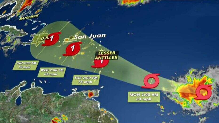
PHILIPSBURG–Sunday at 11:00pm the centre of Tropical Storm Dorian was located near latitude 11.7 North, longitude 55.3 West, or about 700 miles Southeast of St. Maarten. The system is predicted to remain well South of the local area.
Dorian had been moving toward the West near 14 miles per hour (mph) (22 kilometres per hour (km/h)) and this general motion was expected to continue last night. A turn toward the West-Northwest is foreseen today, Monday, and that motion should continue through Tuesday night.
On its latest forecast track the disturbance was expected to be near the Eastern Caribbean islands late today or early Tuesday and move into the Eastern Caribbean Sea on Tuesday. However, according to Meteorological Department St. Maarten (MDS), the storm’s centre was projected to pass about 207 miles to the South early Wednesday and thus posed no immediate threat.
Maximum sustained winds were near 50mph (85km/h) with higher gusts. Some strengthening was forecast during the next few days and Dorian could be near hurricane strength by Tuesday.
Tropical-storm-force winds extended outward up to 45 miles (75km) from the centre and the estimated minimum central pressure was 1,003 millibars (29.62 inches). MDS will continue to monitor this system and keep the public updated.
The Emergency Operations Centre (EOC) met on Sunday afternoon under the chairpersonship of Prime Minister Leona Romeo-Marlin. Emergency Support Functions (ESFs) of the country’s national disaster emergency system met at the Government Administration Building and were briefed by MDS.
The prime minister also received a preliminary update regarding national preparations for the hurricane season from some of the ESFs. The EOC will convene again on Tuesday afternoon, when another statement will be released with respect to the status of Dorian, which up to Sunday evening did not pose a direct threat to the country.
“The community and new residents are urged to learn more about hurricane hazards and how to prepare for a storm/hurricane strike by visiting the government website
www.sintmaartengov.org/hurricane where you will be able to download your ‘Hurricane Season Readiness Guide’ and ‘Hurricane Tracking Chart’,” stated a release from the Department of Communications.
The Office of Disaster Management (ODM) reminded residents and business owners to “have plans in place for quick action when the need arises – storm ready! Remember, it only takes one hurricane to make it a bad season.”
The government of St. Lucia issued a tropical storm warning for St. Lucia. The government of Barbados issued a tropical storm warning for Barbados and for St. Vincent and the Grenadines. The government of Trinidad and Tobago issued a tropical storm watch for Grenada and its dependencies and the government of France issued a tropical storm watch for Martinique.
Dorian is expected to produce total rain accumulations of two to four inches in portions of the Lesser Antilles, with possible isolated maximum amounts of six inches.
Tropical storm conditions are likely in the warning area by late today. Tropical storm conditions are possible within the watch area by tonight or Tuesday.
Swells generated by Dorian will be affecting portions of the Lesser Antilles by late today. These swells could cause life-threatening surf and rip-current conditions.
Bron: Daily Herald